Showing posts with label 5 Days of Making Geography Fun. Show all posts

Friday, April 11, 2014

5 Days of ... Making Geography Fun- Day 5: Fun Geography Resources

April Blog Hop

As I mentioned, there are many more insightful posts to be found. Here is the link to the main post on the Schoolhouse Review Crew blog where you can find a list of everyone who is sharing. To get you started, I invite you to stop by these blogs:

Dawn @ Guiding Light Homeschool ~ Homeschooling with Excessive Energy
Lexi @ Lextin Academy ~ The Homeschool Dad, CEO
Lynn @ Ladybug Chronicles ~ Organizing Your Home and School
Cristi @ Through the Calm and Through the Storm ~ Homeschooling Thankfulness
Melissa@ Mom's Plans ~ Historical Field Trips
Adena @ AdenaF ~ Mnemonics
Amy @ Homeschool Encouragement ~ Lego Learning
Erin @ For Him and My Family ~ Record Keeping


Thursday, April 10, 2014

5 Days of ... Making Geography Fun- Day 4: Country Study for Younger Elementary Children


Welcome to the 4th day of our Making Geography Fun posts. If you have missed my previous posts I invite you to check them out at the following links:

Day 3: On the Road

Last month I let myself get roped into teaching a "Global Art" class in our homeschool co-op for the K-3rd graders. Our lovely leader had asked for a teacher for a History Craft Class. While I wasn't sure exactly what she was looking for, I did tell her I had a book called Global Art by MaryAnn F. Kohl and Jean Potter that I had used during the summer with the children. She liked the sound of the book and the fact that she would be getting me out of my comfort zone to teach an older class. 

At first I had wanted to organize the lessons the same way I had when I was doing the review of Global Art for the TOS Review Crew. Last summer we picked a continent to focus on, found different crafts to make for some of the countries on said continent, plus read books and made a recipe. We also included map skills by coloring in the countries on our map. We had done Africa and Asia, so I thought it might be nice to pick a different continent for our co-op class, perhaps the one where one of our co-op families was going to be going on a missions trip to. The plan was to find some crafts for Central America, check out some library books and perhaps make a snack.

Unfortunately, there weren't really enough doable crafts for our co-op situation that focused on Central America and Guatemala. I was at a loss until the librarian found a book for me called, Geography For Fun: People and Places by Pam Robson.


This book was actually one she found for me when I was searching for books for my Poppins Book Nook lessons for March. While I didn't really use it for Where in the World?, I found a great idea for a Country Profile poster that I thought would be perfect for co-op. We worked on different aspects each week, including one craft from the Global Art book.

Here is my finished Guatemala Poster.


We started out by labeling a world map with all the continents. Then we found Central America on an Outline Map of North America.


We then learned the countries of Central America. I only had the children label Guatemala though. We also discussed what bordered it.


After that short map-skills lesson I read them a bit about the Sawdust Carpets that are mentioned in the Global Art book. I had typed out some information about them, leaving blanks for them to fill in. They could choose to write the correct answers in or cut and paste. Then we followed the directions to make the replica sawdust carpets. We added powdered tempera paint to sawdust and used it like glitter to create a colorful picture.


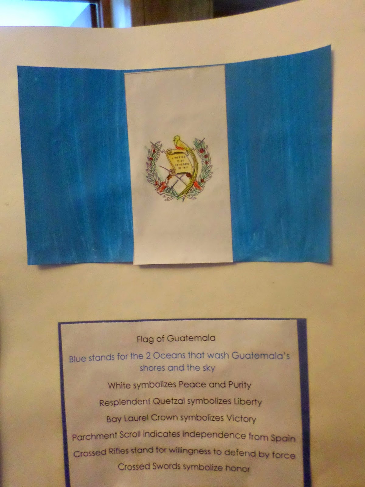
The next week we made Guatemalan flags. I also printed out some information explaining the symbolism on the flags. This time I didn't have them fill anything in. I knew we would need the majority of our time to attach what we had made so far to the posters. Any information that was on computer paper was first mounted on construction paper to help it stand out.


We also learned that Guatemala means "Land of Trees."


The paper on the bottom left was actually added on the third and final week. This was a fill-in-the-blank paper for our last craft, belt weaving, an idea I found in another book.

Here they are working on their weaving:


After they completed their posters on the third week they were able to take them home.

Tabitha's Guatemala Poster


Amelia's Guatemala Poster


It really was a fun way to learn about a country. 

As I mentioned, there are many more insightful posts to be found. Here is the link to the main post on the Schoolhouse Review Crew blog where you can find a list of everyone who is sharing. To get you started, I invite you to stop by these blogs:

Dawn @ Guiding Light Homeschool ~ Homeschooling with Excessive Energy
Lexi @ Lextin Academy ~ The Homeschool Dad, CEO
Lynn @ Ladybug Chronicles ~ Organizing Your Home and School
Cristi @ Through the Calm and Through the Storm ~ Homeschooling Thankfulness
Melissa@ Mom's Plans ~ Historical Field Trips
Adena @ AdenaF ~ Mnemonics
Amy @ Homeschool Encouragement ~ Lego Learning
Erin @ For Him and My Family ~ Record Keeping

April Blog Hop

Wednesday, April 9, 2014

5 Days of ... Making Geography Fun- Day 3: On the Road


We only just arrived home from our trip to the Creation Museum last night, so I wanted to share how we included geography in our trip, because you know, children are always learning, not just during lesson time.

It wasn't anything fancy. We just let the children have a map, which can be found for free at rest stops. 

As we traveled down the road the children would ask where we were and I would show them on the map. I also let them know which direction we had traveled and where we still needed to go. When we stopped at the rest stop we also showed them the map they had on display pinpointing where we were.

The older girls had a pretty good understanding. Hannah just had fun looking at the map.


She thought she was going to be able to find specific places, like restaurants and such. We tried to explain that those kinds of landmarks would not be found on a state map. 


Now that we are home I plan to pull out the map and go over the trip again showing them where we were and seeing if they remember some of the places we stopped. 

If I had done more planning I think I would have marked our trip out on the map with a highlighter and marked some specific roads, intersections and cities. Then, when we past through those places the children could have marked them on the map to get a better feel for how far we had come and how far we still had to go. Poor Tabitha felt like she was going to spend her entire life in the van and we would never get there (she may be a bit on the over-dramatic, worrier side).

So, how to you include learning on road trips?

As I mentioned, there are many more insightful posts to be found. Here is the link to the main post on the Schoolhouse Review Crew blog where you can find a list of everyone who is sharing. To get you started, I invite you to stop by these blogs:

Dawn @ Guiding Light Homeschool ~ Homeschooling with Excessive Energy
Lexi @ Lextin Academy ~ The Homeschool Dad, CEO
Lynn @ Ladybug Chronicles ~ Organizing Your Home and School
Cristi @ Through the Calm and Through the Storm ~ Homeschooling Thankfulness
Melissa@ Mom's Plans ~ Historical Field Trips
Adena @ AdenaF ~ Mnemonics
Amy @ Homeschool Encouragement ~ Lego Learning
Erin @ For Him and My Family ~ Record Keeping

April Blog Hop

Tuesday, April 8, 2014

5 Days of ... Making Geography Fun- Day 2: Postcard Swaps

Welcome back to the 5 Days of Making Geography Fun posts, my small part of the Schoolhouse Review Crew's 5 Days of...Blog Hop. If you missed yesterday's post, I shared about our Interactive Town Map, if your child enjoys hands-on activities I encourage you to check it out. 


Today I would like to share another fun way we have focused on geography.  We have participated in a few different postcard swaps through the years. When the girls were younger we found a blog that was organizing a postcard exchange. We started exchanging some postcards with others and when we recieved the postcards we attached them to the wall around our world map. We used yarn to show where they came from. This exchange was a bit random and we also swapped overseas.  


A bit later I found a swap that was exchanging just in the United States. This was actually my favorite swap. Once every state had someone signed up we started sending postcards out to each other.  Each week 2 people were to send out postcards from their state to everyone else in the swap. Yes, that meant we were sending out 49 postcards at once. However, that also meant we were getting 2 postcards each week. That was the theory anyway, there were  couple of states we never received, but all in all it was a great experience.  I enjoyed the way it was organized. The order we received the postcards was in the order the states joined the union. That made it possible to sign up to use about.com's state study. 

When we received the postcards we located the state on the map, then we colored some state symbols, such as the flower and bird, along with the flag to put in a scrapbook. 

Last summer I decided it would be fun to spend some time on geography again as it had been a couple of years. We put our My Father's World Curriculum aside as planned and had some fun with some more swapping (along with some other geography fun that I will be sharing tomorrow). I discovered a wonderful Facebook Group called  Homeschool Swapping Adventures.  Each month we can comment on threads to find homeschool families who would like to swap postcards, along with other things. The last time I participated we were able to make plans to swap with 10 different families. I again decided to try to get postcards for each state. This time around, when we received the postcard we colored in the state on a United States outline map.

As I mentioned yesterday, there are many more insightful posts to be found. Here is the link to the main post on the Schoolhouse Review Crew blog where you can find a list of everyone who is sharing. To get you started, I invite you to stop by these blogs:

Dawn @ Guiding Light Homeschool ~ Homeschooling with Excessive Energy
Lexi @ Lextin Academy ~ The Homeschool Dad, CEO
Lynn @ Ladybug Chronicles ~ Organizing Your Home and School
Cristi @ Through the Calm and Through the Storm ~ Homeschooling Thankfulness
Melissa@ Mom's Plans ~ Historical Field Trips
Adena @ AdenaF ~ Mnemonics
Amy @ Homeschool Encouragement ~ Lego Learning
Erin @ For Him and My Family ~ Record Keeping

April Blog Hop

Monday, April 7, 2014

5 Days of ... Making Geography Fun- Day 1: Interactive Town Maps


Welcome to the Schoolhouse Review Crew's 5 Day Blog Hop. This time around there is no specific theme, each Crew member will be sharing a subject of their own choosing with a new post each day this week. There are going to be posts like Making Homeschooling Fun,  Family Friendly Finger Food, Babywearing and Clearing Out the Clutter. 

I will be sharing some ways to make geography fun for young children. 

When the girls were younger they really enjoyed watching Dora the Explorer. Originally my thinking was that the show would be a nice introduction to Spanish for the girls. I then realized it is a great show for an introduction to map skills. I love the way there are several landmarks they need to be looking for as Dora and Boots travel to their destination. I thought it would be fun to create a map of our town.


I found an aerial map of our town online and copied the main streets and river into a file folder. We live in a town that is only 1 mile around, so this was pretty easy. For bigger towns or cities you would probably want to concentrate on a smaller area to start with. 

We went around town, taking pictures of important buildings and other landmarks. I printed out 2 copies of each picture. One copy went onto the map and then I covered the entire thing with clear contact paper (the poor man's laminator). Then I "laminated" the second set of pictures so they could be matched onto the map.


The idea is to take the map around town and match the landmarks as you go.   You could also pick one as a destination and two or three others as stops along the route to plan fun activities (sort of like Dora). Another thought is to print a third set out and play a matching/memory game. The last landmark matched can be the destination for a fun trip. 


Though we made the map a few years ago, we just recently used it as we took a walk around town in an attempt to fill in some more details about our town. I posted about this in my Poppins Book Nook post, Map Skills with Mapping Penny's World.


There are many more insightful posts to be found. Just click on the banner below to head to the main post on the Schoolhouse Review Crew blog where you will find a list of everyone who is sharing. To get you started, I invite you to stop by these blogs:

Dawn @ Guiding Light Homeschool ~ Homeschooling with Excessive Energy
Lexi @ Lextin Academy ~ The Homeschool Dad, CEO
Lynn @ Ladybug Chronicles ~ Organizing Your Home and School
Cristi @ Through the Calm and Through the Storm ~ Homeschooling Thankfulness
Melissa@ Mom's Plans ~ Historical Field Trips
Adena @ AdenaF ~ Mnemonics
Amy @ Homeschool Encouragement ~ Lego Learning
Erin @ For Him and My Family ~ Record Keeping

April Blog Hop

Related Posts with Thumbnails